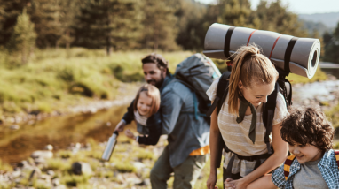
Fun skills to teach kids on holidays
Teaching kids how to understand and use maps while exploring nature can be a great focal point for your open-air family holiday.
Let’s start with an explanation for kids of what maps are:
Maps provide information and reference material for a wide variety of purposes, serving a broad spectrum of professions like engineering and surveying. In everyday life, maps help you understand and navigate streets and terrain by allowing you to identify where you are (point of origin) and how to get to wherever you’re going (point of destination).
There are lots of types of maps: reference maps relating to the physical and geographic features of the earth, and thematic maps on specific topics like weather and natural resources. But for teaching your kids about reading maps, start with the most common types: street maps and topographic maps.
Road and street maps describe the road network of your town or city and can identify where you live, your schools, churches, parks, place of work. When teaching kids about reading maps on holidays, start with campsite maps and local village maps. Or, even better, get going on the journey, bringing along paper maps to spot towns and villages, as you travel through.
Then you can graduate to topographic maps – useful for walking, hiking or driving in unfamiliar territory. These are best for exploring nature with children. We have some suggestions of exciting map-reading games and exercises to make your open-air holiday even more fun and educational too!
A Beginner’s Guide to Map Reading
Key points to assist your kids with understanding maps and how to use them correctly.
How to choose the correct map
Choosing the correct map is entirely dependent on purpose and location: you wouldn’t choose a topographical map to teach your child the way home for example. Road and street maps are great for learning basic navigation and directions in population centres whether walking or driving while topographic maps are essential for exploring nature in unfamiliar territory.
Actual maps versus virtual maps
Since most kids are computer savvy from a young age, using a virtual map on a computer for tutorials is a good way to engage them but there’s nothing better than an actual map for teaching the basics. They should also learn how to navigate when out of range of GPS and Wi-Fi signals.
Basic map reading essentials
Start with the basic information such as the title (general location where you are), the compass rose (identifies the cardinal map points: North, South, East and West so they can view/hold the map correctly) and the legend, which points out important structures like buildings or landmarks as well as rivers and lakes, which can be used as reference points to find their way from point A to point B.
Understanding grid references, contour lines and scales
Getting the hang of these might be difficult at first, so keep it simple and allow them to feel their way through the process. Starting with the alpha and numeric values for grid references is like block games to a child and are easy to understand. Contour lines are numerically graded in intervals and the closer together they appear on a map, the steeper the actual terrain. Scales are crucial for calculating distances based on the map markings so stick to the standard 1:50,000 where 1 cm on the map equals 50,000 cm in actual fact.
Using the key: all about symbols and legends
A good map always has a key or legend that is located usually in the lower right corner and identifies many key physical features, such as mountains and hills as well as marine features including streams, lakes and rivers.
Understanding how GPS and a compass works
Satellite navigational instruments such as GPS technology has made it easier to get around in the modern world and has relegated basic map reading skills to the boot of the car, so to speak. In the wild, however, GPS tracking isn’t always available, so teaching your child to read a map is a handy skill. It can make all the difference between getting there and getting lost, especially when hiking long distances among elevated terrain and woodland areas, which can be disorienting.
Hands-on tutorials
Choosing a route on your map with a good mixture of features and identifying them as you go is a great way for children to get some practical experience with map reading. Pause every now and then to fix your bearings using a compass or grid references and teach them how to use distinguishing map features like signposts.
Be patient, encourage them and make it fun
Kids are eager learners when subject matter is new and exciting, but they do make mistakes so remember to be patient when teaching them about maps and always throw a bit of humour in the mix to keep things relaxed and always remember that a little bit of encouragement goes a long way.
Exciting Map Reading Games and Exercises for Kids
Once you’re reviewed the basics, use these map reading games and exercises to wrap their minds and brains around it all.
Map symbol bingo
This is a fun way to teach identification of map symbols using symbols instead of numbers on cards you create yourself or download some games on the computer. They can win crossing off vertical or horizontal lines then work your way up to the full card. Map symbol bingo games are available (or can be created) in easy, intermediate and difficult versions for kids from about age five and upwards.
Treasure hunts at home
Another fun way for younger kids to develop map reading skills is to create treasure hunts on holidays. Use your environment to get creative with your map drawings to indicate directions and using legends to highlight guideposts along the way. For older kids, you can organise these hunts around the immediate campsite which is good practical practice for outdoor orientation.
Navigating parks and campsites
Once they’ve mastered the basics, why not have them navigate your open-air location. On a blank sheet of paper have them mark or draw the locations of swimming pools, beaches, ice-cream shops or their own chalet. Use a sliding scale from 1 to 10 to award points for exact locations, accurate depictions and number of identifications including surrounding buildings and landmarks if any.
Find your way home
Mastery of the local territory means it’s time to graduate to actual courses. Mark out a moderately simple path, walk to the end of it and then give the map over and have them find the way back. If you’re in a location with several different pathways, you can have them find an alternate route back from the one you used and make sure there’s a reward or other form of compensation for a job well done.
You be the guide
By this stage, depending on the age of the child, you can judge how far they’ve come by giving points of origin and destination and let them map out the route on paper before actually taking the course together to see just how accurate the directions are. Throw in a couple of teaser questions about directions and distances along the way to judge their level of confidence and ability to make calculations off the cuff.
Tips for exploring nature with children
As the tutor, you can never have enough information, so here are a few key things:
What’s the difference between magnetic north and true (grid) north?
This is one of the most basic principles when it comes to reading maps at any age and knowing the difference is key. Magnetic north indicated by a compass is not a fixed direction and varies slightly over time according to variations in the earth’s magnetic field whereas true or grid north is the actual direction used by mapmakers, which is always standard.
Is using a compass necessary for reading a map?
No, it isn’t. Any good map can be used to teach a child the fundamentals of map reading without the aid of a compass. In fact, many would recommend that you only use a compass as an additional tool in the skillset as opposed to having children rely on them. This way, they become fully engaged in the art of reading maps without reliance on any external factors like compasses or GPS.
How can I tell what sort of map I have?
If it isn’t obvious simply by looking at it, you can always tell what sort of map you have by its distinguishing features. For example, tourist maps always indicate points of interest, public transport hubs and popular landmarks while road and street maps indicate highways and byways for vehicular traffic. Topographic maps, however, are mainly interest in physical and geographic features on the ground.
Is it ok to use maps with colours and pictures?
Maps with colours and pictures are basic maps more relevant to younger children than older ones but there’s no reason why they can’t be used for teaching the fundamentals of map reading.
Are six-figure grid maps better than four-figure grid ones?
Not necessarily. Most 1:50,000 scale maps use a six-figure grid reference, which measure distances to a finer degree than the four-figure grid reference system. However, these have no bearing on your or your child’s ability to read a map.
If you’re keen to do some further reading, we found these resources interesting:
https://getoutside.ordnancesurvey.co.uk/guides/beginners-guides-map-reading/
https://www.travelandleisure.com/travel-tips/navigation-how-to-read-maps